PLACE SV-P-0000102
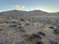
Upper Duck Creek Detention Basin
14 page views
ABOUT THIS PLACE
Upper Duck Creek Detention Basin is recorded in the Captain SkyView archive as a Natural. SkyView currently contains 5 public artifacts with a public location inside this place area.
PLACE DETAILS
Upper Duck Creek Detention Basin
- Type
- Natural
- Location
- Upper Duck Creek Detention Basin
- Map point
- 36.00671, -115.31603
- Map area
- Point radius (3,280 ft)
- Source
- Overpass
- Source ID
- way:709793437
- Source refreshed
- October 19, 2026
LANDSCAPE TOPICS
What is documented here
Alluvial sediment, undifferentiated geologyPsc geologyPse geologyQa geologySedimentary rocks geologyArgenteria Mine mineBlue Diamond Mine mineBlue Jay Mine mineColumbia Mine mineContact Mine mineCopper Glance Mine mineCosmopolitan Claim mineCrystal Pass Prospect mineDawn Mine mineDoubleup Mine mineFarmers Group of Claims mineGreen Copper Mine mineHermosa Claim mineHoughton Mine mineIreland Mine mineLincoln Mine mineLookout Mine mineMiddlesex Mine mineNinety-Nine Mine minePauline Mine minePilgrim Mine minePotosi Mine minePrairie Flower Mine mineQuo Vadis mineRadium Deposit mineRed Cloud Mine mineRuth Mine mineSloan Limestone Quarry mineSnowstorm Mine mine
INSIDE THIS PLACE
Artifacts in this area
5 public artifacts whose public location falls inside this Place.